Cartographic Relief Representation
Summary
Shaded relief is used in cartography to depict topography and is produced by traditional manual methods or by computer computations based on digital elevation models. The goal of this project is the development of algorithms for the effective cartographic depiction of terrain in two- and three-dimensional maps. Research has been conducted in three areas.
(1) Methods for relief shading for traditional two-dimensional maps adapting well-proven design principles of manual relief shading, such as local adaptations of the light direction, or the simulation of aerial perspective.
(2) Algorithms and methods for interactively colorising grayscale shaded relief.
(3) Development of specialized projections for producing 3D-maps from digital elevation models.
Results
(1) We have successfully implemented and tested a prototype software application for interactive analytical relief shading. It provides the possibility to locally adapt the shading, permitting a seamless control throughout the whole processing. Tests with the program have shown, that with little time invested, the quality of analytically shaded reliefs can be improved significantly (figures 3, 4 and 5).
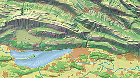
(2) An algorithm has been developed for colorsing grayscale shaded relief. A prototype software application containing the developed algorithm has been successfully used for colorising a shaded relief for the new school map of the Canton of Schaffhausen (figure 1).
(3) A novel plan oblique relief projection has been programmed and used for the rendering of a bird's-eye view map of Switzerland (figure 2).
Project period
01.01.2001 – ?
Researchers
Lead: Hurni, Lorenz
Internal: Jenny, Bernhard. Räber, Stefan.
Funding sources
Own resources of the professorship
Partner
externe SeiteOregon State University, Cartography and Visualization Group
Web
externe Seitewww.reliefshading.com
externe Seitewww.terrainmodels.com
externe Seitewww.shadedreliefarchive.com
Publications
BirdLife Switzerland and Institute of Cartography ETH. Biodiversität erleben – Die Naturschutzzentren und andere Naturerlebnisorte der Schweiz und ihrer Nachbarschaft. 2006.
Hurni, Lorenz; Jenny, Bernhard; Dahinden, Tobias; Hutzler, Ernst. Interactive Analytical Shading and Cliff Drawing: Advances in Digital Relief Presentation for Topographic Mountain Maps. Proceedings of the 20th International Cartographic Conference, ICC 2001 Bejing. 2001.
Jenny, Bernhard. Bringing Traditional Panorama Projections from the Painter’s Canvas to the Digital Realm. Proceedings - 4th ICA Mountain Cartography Workshop, Nuria, Spain. 2004.
Jenny, Bernhard. Computergestützte Schattierung. Proceedings of the ICA-Commission on Mountain Cartography, Kartographischer Baustein, Vol. 18. TU Dresden, Deutschland. 2000.
Jenny, Bernhard. Estompage assisté par ordinateur. Vermessung Photogrammetrie Kulturtechnik. 2000.
Jenny, Bernhard. Räber, Stefan. www.reliefshading.com. 2005.
Jenny, Bernhard. Design of a Panorama Map with Plan Oblique and Spherical Projection. Association of Surveyors of Slovenia, Section for Cartography and University of Ljubljana, Faculty of Civil and Geodetic Engineering. Ljubljana, Slovenia. P. 121-128. 2006.
Jenny, Bernhard; Hurni, Lorenz. Swiss-Style Colour Relief Shading Modulated by Elevationand by Exposure to Illumination. The cartographic journal. Maney Publishing, Leeds, UK. P.198-207. 2006.
Jenny, Bernhard; Patterson, Tom. Introducing Plan Oblique Relief. Cartographic Perspectives, Vol. 57. North American Cartographic Information Society, Milwaukee, WI, USA. P.21-40. 2007.
Jenny, Bernhard. Räber, Stefan. Sutter, Felix. Terrain Models. www.terrainmodels.com. 2006.
Vermessungsamt Schaffhausen and Institute of Cartography, ETH Zurich. Schulkarte Kanton Schaffhausen. 2005.
Wäger+Partner GmbH and Institute of Cartography. Drei-Seen-Land. HPM-Karte 1:100,000. 2002.